High resolution Late Pleistocene fluvial archives in SE Spain
| Investigators: | Lothar Schulte, Ramon Julià, Francesc Burjachs, Alexandra Hilgers, Felipe Carvalho |
| Period: | 1995 - ongoing |
| Funding: | diverse, mainly from the Catalan Government (FI/96-1.255) and the University of Barcelona; dating provided by Earth Science Institute Jaume Almera and University of Cologne |
Scientific highlights
Travertine and high resolution Late Pleistocene fluvial archives
The chronology of fluvial erosion and deposition has the potential to identify tectonic, climate and human-induced environmental changes. The development of river systems can be considered in terms of specific climatic parameters: climate-derived factors, partially climate-dependant factors, and non-climatic factors. The aim of this project is first to research evidences about the origin of fluvial erosion and aggradation processes of the middle and lower River Aguas in southeastern Spain.
The 539 km2 catchment of the River Aguas covers the eastern Sorbas basin and the southern Vera basin, located between 37º20’N and 37º2’N and between 2º9’W and 1º48’W and it is located on the tectonically active eastern margin of the Betic Ranges (Fig. 1).
We focused on two questions:
- Firstly, do fluvial archives in southeast Spain provide sensitive records of climate changes during the last 170 thousand years? Therefore, our concern is to provide high-resolution paleoclimate proxis from alluvial and fluvial records.
- And secondly, how do climate, sealevel changes and tectonics affect fluvial dynamics?
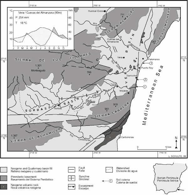
Figure 1: Geographical location of the study area. 1 = Alfaix travertine sequence. 2 = Fluvial terrace T4a at Rambla de los Hornos. 3 = Rambla Ancha site. 4 = LGM/Holocene terrace intersection at 4 km to the coastline.
Our results from the River Aguas basin suggest that fluvial archives, travertine and slope deposits provide sensitive resolution records of environmental changes during the last 170 kyr. From the chronostratigraphic data sets we have established a model of middle and late Pleistocene river response for littoral basins on the southern Iberian Peninsula (Fig. 2). U/Th and OSL dating indicate the major periods of travertine formation of the Alfaix travertine platform, which range from 169 to 26 kyr. At least four incision events interrupted this aggradation period: between 167 and 148 kyr, between 148 and 110 kyr, around 95 kyr and at 71 kyr. Aggradation ceased after 26 kyr and incision occurred during OIS 2. Subsequently, the terraces T4a and T4b were deposited. OSL dating of the T4a channel deposit provides maximum ages of 28, 20 and 18 kyr. However, short climatic events, such as the Younger Dryas, produced two more river incision episodes during OIS 2.
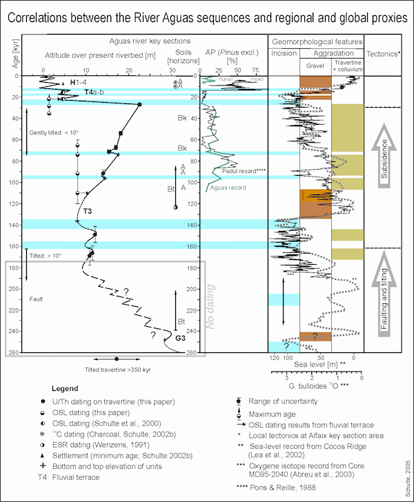
Figure 2: Correlations between the River Aguas sequences and regional and global proxies.
Nonetheless, for river systems influenced by tectonics, climate and sea-level changes it is difficult to assess the weight of each controlling factor. Regarding the three mechanisms of Pleistocene river dynamics in middle-size catchment areas of the littoral of southeastern Spain, our results support the hypothesis that large scale tectonics triggered the general downcutting trend, whereas the main aggradation and incision phases occurred during periods of major sea-level changes. At short-time scales the influence of climate variability, as documented by pollen records, plays a decisive role. Thus, the river responses to the three cyclic mechanisms operate at different time scales.
The available age constraints suggest that terrace deposition was related to major environmental changes from OIS 6 to OIS 5 (terrace T3) and from OIS 2 to OIS 1 (terraces T4 and T4b) although Holocene sea-level and climate changes also produced valley fills.
New studies from alluvial deposits form the lower River Aguas near Turre show a sensitive response of aggradation, soil formation and sediment geochemistry to Late Pleistocene and Holocene climate variability since isotope substage OIS 5a (Fig. 3). At present our geochronological model of the upper profile is performed by radiocarbone ages. The lower chronology, based on correlation with 18O records, will be improved by OSL dating.
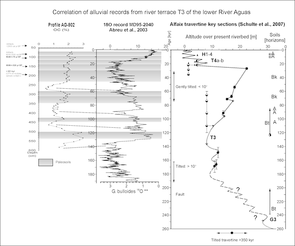
Figure 3: Correlations between the alluvial sequence AG-902, the regional River Aguas sequence and global proxies.
References
Schulte, L., Julià, R., Oliva, M., Burjachs, F., Veit, H., & Carvalho, F. 2008. Sensitivity of Alpine fluvial environments in the Swiss Alps to climate forcing during the Late Holocene. Sediment Dynamics in Changing Environments (Proceedings of a symposium held in Christchurch, New Zealand, December 2008). IAHS Publ. 325. pp. 367-374.
Santisteban, J. I., Schulte, L., 2007. Fluvial networks of the Iberian Peninsula: a chronological framework. Quaternary Science Reviews 26, 2738-2757.
Schulte, L., 2002. Climatic and human influence on river systems and glacier fluctuations in southeast Spain. Quaternary International 93-94, 85-100.
Schulte, L., 2002. Evolución cuaternaria de la depresión de Vera y de Sorbas oriental (SE-Península Ibérica): reconstrucción de las fluctuaciones paleoclimáticas a partir de estudios morfológicos y edafológicos. Publicaciones de la Universidad de Barcelona, Barcelona. 251 pp.
Quaternary Soil Chronosequence
Soil studies can contribute to the geomorphologic interpretation of a basin and allow the reconstruction of its chronostratigraphic evolution and modelling. A Quaternary soil chronosequence of the Aguas river terrace has been established, and it seems to be typical for the Vera basin. The chronology of the fluvial sequence of 15 geomorphological units was determined by geomorphologic and sedimentologic criteria, 14C, 210Pb, U/Th disequilibrium dating and artifacts (Fig. 4). The soil chronosequences studied in the Aguas and Antas valley and near the coastline of the Vera basin levels extend from the older (early Pleistocene) well developed Red Mediterranean soils (Rhodoxeralfs, Fig. 5) with argillic Bt horizons to the less developed Holocene Haploxerolls.
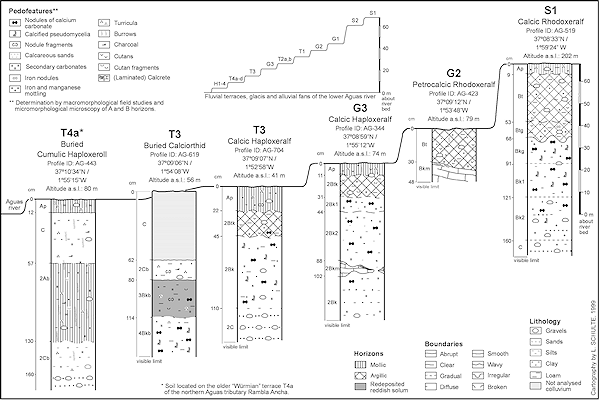
Figure 4: Analysed soil profiles and their morphostratigraphical location on the Aguas river terraces.
In particular, the red paleosols on the older terraces, classified as early Pleistocene, reveal pedologic processes such as leaching, rubefaction, clay formation and illuviation (Fig. 6). Their Bt horizons, whose preserved thickness does not exceed 60 cm, are decalcified, with a redness rating of 15 and high Fet and Al contents. Frequent (degraded) clay coatings provide evidence of clay illuviation. In general, the higher the ground mass content of the Bt horizons, the older the surface. This phenomenon is also evidenced by the presence of an angular blocky or prismatic structure.
The reddish brown to yellowish red Haploxeralfs on the middle Pleistocene terraces are less developed than the Rhodoxeralfs on the early Pleistocene alluvial fans and glacis (Fig. 4 and 6). Their redness rating ranges between 3.5 and 11.25 and the Al2O3 content shows lower values. Degraded clay coatings were also observed in thin sections, although with less frequency. The calcic and petrocalcic horizons of the Haploxeralfs are well developed and have CaCO3 contents between 30 and 40% and sometimes greater.
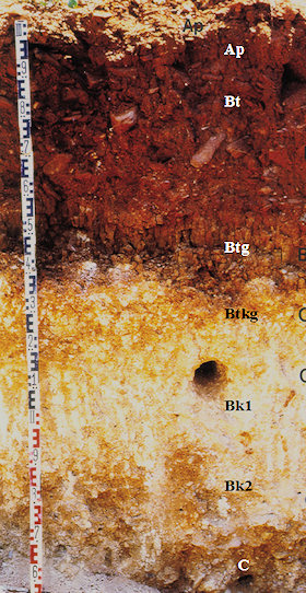
Figure 5: Profile of a Calcic Rhodoxeralf (Ap-Bt-Btg-Bkg-Bk1-Bk2-C) developed on an Early Pleistocene alluvial fan near Los Llanos (River Aguas).
Haploxerolls were detected on the surfaces of stages 2 and 1 terraces where soils were not excessively transformed by human activity. Organic carbon reaches maximum values of 1.8%. The most remarkable pedofeature is the abundant worm casts with diameters of up to 1.7 cm and frequent turricula.
A chronological argument for the increasing soil development with age can also be provided by the multivariate analysis applied to the data matrix, defined by the chemical composition (CaCO3, Al2O3, P2O5, K2O, CaO, SiO2, TiO2, MnO, Fe2O3, MgO, Na2O) and the redness rating as variables and by the 35 samples taken in the pedological horizons as individuals.
Pedological dynamics bear a more or less close relationship to climatic change and permit a reconstruction of the Quaternary environment of the Vera basin. Although the intensive development of the older paleosols has been attributed to the greater length of pedogenic processes since terrace accumulation, it can also be ascribed to more favorable (seasonal hot/dry and more humid) climatic conditions during early Pleistocene as confirmed by Mediterranean 18O isotope records (Vergnaud Grazzini et al., 1990).
The paleoclimatologic interpretation of the analyzed red paleosols agrees with the results of Courty et al. (1994), who studied a Red Mediterranean soil on a middle terrace of the Almanzora river in the northern part of the Vera basin. On the basis of microlaminated clay coatings and intensive rubiefaction of the Bt horizon these authors suggested a climate which was humid enough to favour dense vegetation cover, in spite of hot and dry summers. Morphostratigraphic mapping shows that the surface corresponds to the glacis G3 of the Antas river (Schulte, 1995), which is approximately an early/middle Pleistocene boundary age (Fig. 6).
In the upper Antas catchment a sequence of four buried paleosols of the early Pleistocene "Glacis G1" includes Rhodoxeralfs, which have not been found on or in the middle Pleistocene terraces. The repeated change from edaphogenesis and burring indicates the relatively short time necessary for the development of Red Mediterranean soils under certain environmental conditions.
The relict soils of the study area undergo a gradual decline in the redness rating from the lower to late Pleistocene, although differences between the Aguas, Antas valley and the coastline were detected. Rubefaction seems to be more intensive on the coast than in the basin centre. Lithologic and microclimatic variations could have played an important role. Soil development on the middle Pleistocene terraces is less effective, probably because of lower temperatures and drier conditions during the middle and late Pleistocene, which were evidenced by loess deposits (Brunnacker, Lozek, 1969; Brosche, Walter, 1977) and pollen records (Menéndez Amor, Florschütz, 1964; Pons, Reille, 1988; Pérez-Obiol & Julià, 1992). However, the middle Pleistocene Haploxeralfs also show reddish Bt horizons with clay illuviation and thick Ck horizons. These data coincide with the pedological results of other studies from Southern Spain. The existence of better developed red soils on early Quaternary surfaces of the nearby Sorbas basin has also been reported by Harvey et al. (1995). In addition, recent paleopedological studies of paleosols of alluvial fans from the Granada basin (S-Spain), undertaken by Günster, Skowronek (1998), point out more intensive pedogenesis (red and brown soils) during early Pleistocene and less intensive soil formation (reddish yellow and brown soils) during middle and late Pleistocene. The increase in climatic and geomorphic contrast during the middle and late Quaternary in the Vera basin is evidenced by a sequence of several fluvial terraces, including periods of accumulation and incision of the Aguas river.
The environmental reconstruction for late Pleistocene and Holocene of the Vera basin is more precise. The youngest Haploxeralf was formed on the fluvial terrace T3, which corresponds to isotopic stage 6. This soil probably developed during isotopic stage 5 (Fig. 6). Likewise, Haploxeralfs were formed on the 9 m marine terrace, where an age of 100,000 6500 yr B.P. was reported by Goy and Zazo (1986). Given its morphostratigraphic position, the soil dates are subsequent to stage 5c or 5e.
Reddish soils whose dates were clearly younger than stage 5a were not found in the Vera basin. The soil formation probably correlates with one of the main periods of travertine formation, which fall within 88,000 4000 - 94,000 5000 yr B.P. (stage 5a). Even palynological studies of selected travertine samples point to a more humid climate during stage 5a and at the beginning of stage 3.
Leaching of carbonates occurred during the last glacial cycle subsequent to 70,000 yr B.P. and still after 54,000 yr B.P., whereas no calcic horizons were found in stages 2 and 1 sediments. The following reasons, amongst others, could account for the restriction of these pedological dynamics: the general lack of sufficient precipitation and the intervention of morphological (accumulation/erosion) processes.
The maximum soil development since OIS 3 is represented by a late Glacial - early Holocene Haploxeroll, with abundant biological pedofeatures but without carbonate removal. Several pollen records (Burjachs et al., 1997; Roca, Julià, 1997; Pantaleón-Cano, 1997) from the Mediterranean catchments of the Iberian Peninsula indicate a more humid climate at the beginning of Holocene. Nevertheless, the environmental conditions seem to have been too dry for an intense soil and travertine development during the last 10,000 years.
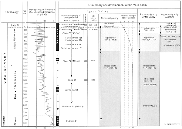
Figure 6: Quaternary soil development of the Vera basin. The pediment P1 is regarded as upper Pliocene. In the north-eastern part of the Vera basin an age of 2.358 myr B.P. was obtained for the base of the oldest alluvial fan and an age of 1.624 myr B.P. (ESR) for the "Glacis G1" (Wenzens, 1992b). The alluvial fan S2 is located morphostratigraphically between these two geomorphologic units. The U-series dating method gives ages of 169,000, 167,000 and 148,000 myr B.P. for the fluvial terrace T3. The morphological levels differentiated between G2 and G3 developed from latest early Pleistocene to middle Pleistocene. An age of 100,000 yr B.P. (U/Th) was reported by Goy and Zazo (1986) for the 9 m marine terrace. The Würm terraces T4 were accumulated after 54,700 yr B.P. The arrows of the morphostratigraphic column represents the chronostratigraphic range of the terrace levels which were not radiometrically dated. Their order in the column corresponds to the relative morphostratigraphic sequence.
References
Schulte, L., 2002. Evolución cuaternaria de la depresión de Vera y de Sorbas oriental (SE-Península Ibérica): reconstrucción de las fluctuaciones paleoclimáticas a partir de estudios morfológicos y edafológicos. Publicaciones de la Universidad de Barcelona, Barcelona. 251 pp.
Schulte, L. & Julia, R., 2001. A Quaternary soil chronosequence of Southeastern Spain. In: Zeitschrift für Geomorphologie. N.F. 45 (2), pp 145-158.
Schulte, L., 1998. Holocene fluvial dynamic of the Río Aguas. In: Castro, P.V., Chapman, R.W., Gili, S., Lull, V., Micó, R., Rihuete, C., Risch, R., Sanahuja Yll, M.E. (Eds.), Aguas Project. Paleoclimatic reconstruction and the dynamics of human settlement and land-use in the area of the middle Aguas (Almería), in the south-east of the Iberian Peninsula. European Commission, D.G.XII, Brussels, p. 45.
Schulte, L. et al. 2019.
Integration of multi-archive datasets towards the development of a four-dimensional paleoflood model in alpine catchments.
Global and Planetary Change 180, 66-88.
Peña, J.C.; Schulte, L., 2020.
Simulated and reconstructed atmospheric variability and their relation with large Pre-industrial summer floods in the Hasli-Aare catchment (Swiss Alps) since 1300 CE.
Global and Planetary Change 190, 103191.
Schulte, L. et al., 2019.
Pluridisciplinary analysis and multi-archive reconstruction of paleofloods: societal demand, challenges and progress.
Global and Planetary Change 177, 225-238.
Blöschl, G. et al. 2020.
Current European flood-rich period exceptional compared with past 500 years.
Sánchez-García et al. 2019.
500-year flood history in the arid environments of south-eastern Spain. The case of the Almanzora River.
Global and Planetary Change, 102987.
Schulte, L. et al. 2015.
A 2600-year history of floods in the Bernese Alps, Switzerland: frequencies, mechanisms and climate forcing.
Hydrology and Earth System Sciences 19, 3047-3072.
Peña, J.C. et al. 2015.
Influence of solar forcing, climate variability and atmospheric circulation patterns on summer floods in Switzerland.
